
Berkas:Bog Asphodel - geograph.org.uk - 1402752.jpg
Bog_Asphodel_-_geograph.org.uk_-_1402752.jpg (640 × 480 piksel, ukuran berkas: 118 KB, tipe MIME: image/jpeg)
Ringkasan
| Deskripsi |
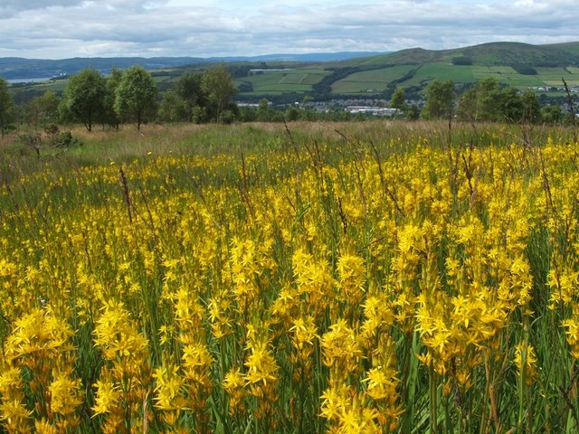
English: Bog Asphodel This is a closer view of some of the flowers that make up an extensive patch of Bog Asphodel (Narthecium ossifragum) on the grassy moors below Pappert Hill: 1402750.
This is a native species, found in bogs and other wet acidic habitats. After flowering, the dried-up remnants of the plant retain a strong orange-yellow colouring for quite some time. The specific name 'ossifragum' means 'bone-breaker'; as is explained in Richard Mabey's "Flora Britannica", that name is indirectly related to the habitat in which the plant is found: "it derives from the belief that grazing the plant made the bones of sheep brittle – though it was not bog asphodel which caused this, but the sour calcium-poor pastures in which it occurs". As for the background, a small part of the River Clyde can be seen at the far left. Slightly to the left of centre, visible as little more than a thin pale-blue line near the top of a hill, is Carman Reservoir. The hills to the right of centre are Carman Hill and Overton Muir. |
| Tanggal | |
| Sumber | From geograph.org.uk |
| Pembuat | Lairich Rig |
| Atribusi (required by the license) | Lairich Rig / Bog Asphodel / |
| Lokasi kamera | | Lihat gambar ini dan gambar di sekitarnya di: OpenStreetMap |
|---|
_heading:247.00&language=id)
| Lokasi objek | | Lihat gambar ini dan gambar di sekitarnya di: OpenStreetMap |
|---|
_heading:247.00&language=id)
Lisensi

|
This image was taken from the Geograph project collection. See this photograph's page on the Geograph website for the photographer's contact details. The copyright on this image is owned by Lairich Rig and is licensed for reuse under the Creative Commons Attribution-ShareAlike 2.0 license.
|
- Anda diizinkan:
- untuk berbagi – untuk menyalin, mendistribusikan dan memindahkan karya ini
- untuk menggubah – untuk mengadaptasi karya ini
- Berdasarkan ketentuan berikut:
- atribusi – Anda harus mencantumkan atribusi yang sesuai, memberikan pranala ke lisensi, dan memberi tahu bila ada perubahan. Anda dapat melakukannya melalui cara yang Anda inginkan, namun tidak menyatakan bahwa pemberi lisensi mendukung Anda atau penggunaan Anda.
- berbagi serupa – Apabila Anda menggubah, mengubah, atau membuat turunan dari materi ini, Anda harus menyebarluaskan kontribusi Anda di bawah lisensi yang sama seperti lisensi pada materi asli.
Riwayat berkas
Klik pada tanggal/waktu untuk melihat berkas ini pada saat tersebut.
| Tanggal/Waktu | Miniatur | Dimensi | Pengguna | Komentar | |
|---|---|---|---|---|---|
| terkini | 1 Maret 2011 11.49 | | 640 × 480 (118 KB) | GeographBot | == {{int:filedesc}} == {{Information |description={{en|1=Bog Asphodel This is a closer view of some of the flowers that make up an extensive patch of Bog Asphodel (Narthecium ossifragum) on the grassy moors below Pappert Hill: 1402750. This is a na |
Penggunaan berkas
Halaman berikut menggunakan berkas ini:
Penggunaan berkas global
Wiki lain berikut menggunakan berkas ini:
- Penggunaan pada be.wikipedia.org
- Penggunaan pada cs.wikipedia.org
- Penggunaan pada en.wikipedia.org
- Penggunaan pada fr.wikivoyage.org
- Penggunaan pada it.wikipedia.org
- Penggunaan pada nn.wikipedia.org
- Penggunaan pada uk.wikipedia.org
- Penggunaan pada vi.wikipedia.org