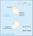
Berkas:Saint Pierre and Miquelon map.gif
Tampilan
Saint_Pierre_and_Miquelon_map.gif (330 × 354 piksel, ukuran berkas: 7 KB, tipe MIME: image/gif)
Riwayat berkas
Klik pada tanggal/waktu untuk melihat berkas ini pada saat tersebut.
| Tanggal/Waktu | Miniatur | Dimensi | Pengguna | Komentar | |
|---|---|---|---|---|---|
| terkini | 26 Juni 2005 08.08 |  | 330 × 354 (7 KB) | Taichi | This is a map of Saint-Pierre and Miquelon from the CIA World Factbook (retrieved from http://www.cia.gov/cia/publications/factbook/geos/sb.html). According to the copyright notice on the website, all information of the World Factbook is in the public do |
Penggunaan berkas
Halaman berikut menggunakan berkas ini:
Penggunaan berkas global
Wiki lain berikut menggunakan berkas ini:
- Penggunaan pada be-tarask.wikipedia.org
- Penggunaan pada be.wikipedia.org
- Penggunaan pada bn.wikipedia.org
- Penggunaan pada ca.wikipedia.org
- Penggunaan pada cs.wikipedia.org
- Penggunaan pada dsb.wikipedia.org
- Penggunaan pada el.wikipedia.org
- Penggunaan pada en.wikipedia.org
- Penggunaan pada eo.wikipedia.org
- Penggunaan pada es.wikipedia.org
- Penggunaan pada eu.wikipedia.org
- Penggunaan pada fa.wikipedia.org
- Penggunaan pada fi.wikipedia.org
- Penggunaan pada fo.wikipedia.org
- Penggunaan pada hu.wikipedia.org
- Penggunaan pada incubator.wikimedia.org
- Penggunaan pada io.wikipedia.org
- Penggunaan pada it.wikipedia.org
- Penggunaan pada ja.wikipedia.org
- Penggunaan pada kk.wikipedia.org
- Penggunaan pada ko.wikipedia.org
- Penggunaan pada ko.wiktionary.org
- Penggunaan pada ky.wikipedia.org
- Penggunaan pada lt.wikipedia.org
- Penggunaan pada mk.wikipedia.org
- Penggunaan pada nl.wikipedia.org
- Penggunaan pada nn.wikipedia.org
- Penggunaan pada no.wikipedia.org
- Penggunaan pada os.wikipedia.org
- Penggunaan pada pl.wikipedia.org
- Penggunaan pada pl.wiktionary.org
- Penggunaan pada pt.wikipedia.org
- Penggunaan pada ro.wikipedia.org
- Penggunaan pada ru.wikipedia.org
- Penggunaan pada simple.wikipedia.org
Lihat lebih banyak penggunaan global dari berkas ini.


