Rumson, New Jersey
Rumson, New Jersey | |
|---|---|
 Lauriston | |
 Peta Rumson di County Monmouth. Selipan: Lokasi County Monmouth ditandai di Negara Bagian New Jersey. | |
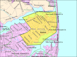
 Peta Rumson, New Jersey oleh Biro Sensus | |
| Koordinat: 40°21′43″N 74°00′14″W / 40.362°N 74.004°W[1][2] | |
| Negara | |
| Negara bagian | |
| County | Monmouth |
| Inkorporasi | 18 Juni 1907 |
| Pemerintahan | |
| • Jenis | Borough |
| • Badan | Dewan Borough |
| • Wali kota | Joseph K. Hemphill (R, jabatan berakhir 31 Desember 2023)[3][4] |
| • Administrator / Petugas kota | Thomas S. Rogers[5] |
| Luas | |
| • Total | 7,11 sq mi (18,42 km2) |
| • Luas daratan | 5,07 sq mi (13,12 km2) |
| • Luas perairan | 2,04 sq mi (5,30 km2) 28.76% |
| Peringkat | ke-242 dari 565 di negara bagian ke-16 dari 53 di county[1] |
| Ketinggian | 36 ft (11 m) |
| Populasi | |
| • Total | 7.343 |
| • Perkiraan | 7.230 |
| • Peringkat | ke-309 dari 565 di negara bagian ke-23 dari 53 di county[12] |
| • Kepadatan | 1.449,2/sq mi (5,595/km2) |
| • Peringkat kepadatan | ke-340 dari 565 di negara bagian ke-41 dari 53 di county[12] |
| Zona waktu | UTC−05:00 (Timur (EST)) |
| • Musim panas (DST) | UTC−04:00 (Timur (EDT)) |
| Kode ZIP | |
| Kode area telepon | 732[15] |
| Kode FIPS | 3402565130[1][16][17] |
| ID fitur GNIS | 0885381[1][18] |
| Situs web | www |
Rumson adalah borough di County Monmouth, di negara bagian New Jersey, AS, dan merupakan bagian dari New York Metropolitan Area. Menurut sensus Amerika Serikat 2020, populasi borough berjumlah 7,343,[9][10] kenaikan sebanyak 221 (+3.1%) dari sensus 2010 yang berjumlah 7,122,[19][20] yang pada gilirannya merupakan penurunan sebanyak 15 (−0.2%) dari 7,137 pada tahun 2000.[21]
Rumson dibentuk oleh undang-undang Badan Legislatif New Jersey pada 15 Maret 1907, dari sebagian Township Shrewsbury, berdasarkan hasil referendum yang diadakan tanggal 18 Juni 1907.[22][23]
Borough ini merupakan salah satu komunitas berpendapatan tertinggi di negara bagian tersebut.[24] Dalam American Community Survey 2013–2017, Rumson memiliki pendapatan rumah tangga rata-rata sebanyak $158,229 (peringkat ke-24 di negara bagian) dan termasuk 43.9% pendapatan rumah tangga lebih dari $200,000 setiap tahunnya.[25]
Rumson berada di antara tagihan pajak properti tahunan tertinggi di New Jersey, dan merupakan yang tertinggi di County Monmouth, dengan $20,602 pada tahun 2018, dibandingkan dengan rata-rata negara bagian sebanyak $8,767.[26]
Pada tahun 2010, Forbes.com meletakkan Rumson di peringkat ke-192 dalam daftar "America's Most Expensive ZIP Codes", dengan harga rumah rata-rata $1,104,271.[27]
Rujukan
[sunting | sunting sumber]- ^ a b c d 2019 Census Gazetteer Files: New Jersey Places, United States Census Bureau. Accessed July 1, 2020.
- ^ US Gazetteer files: 2010, 2000, and 1990, United States Census Bureau. Accessed September 4, 2014.
- ^ Kesalahan pengutipan: Tag
<ref>tidak sah; tidak ditemukan teks untuk ref bernamaMayorCouncil - ^ 2023 New Jersey Mayors Directory, New Jersey Department of Community Affairs, updated February 8, 2023. Accessed February 10, 2023.
- ^ Office of the Borough Clerk, Borough of Rumson. Accessed March 11, 2023.
- ^ Kesalahan pengutipan: Tag
<ref>tidak sah; tidak ditemukan teks untuk ref bernamaDataBook - ^ "ArcGIS REST Services Directory". United States Census Bureau. Diakses tanggal October 11, 2022.
- ^ USGS GNIS: Borough of Rumson, Geographic Names Information System. Accessed March 11, 2013.
- ^ a b c Kesalahan pengutipan: Tag
<ref>tidak sah; tidak ditemukan teks untuk ref bernamaCensus2020 - ^ a b Kesalahan pengutipan: Tag
<ref>tidak sah; tidak ditemukan teks untuk ref bernamaLWD2020 - ^ Kesalahan pengutipan: Tag
<ref>tidak sah; tidak ditemukan teks untuk ref bernamaPopEst - ^ a b Population Density by County and Municipality: New Jersey, 2020 and 2021, New Jersey Department of Labor and Workforce Development. Accessed March 1, 2023.
- ^ Look Up a ZIP Code for Rumson, NJ, United States Postal Service. Accessed July 19, 2012.
- ^ Zip Codes, State of New Jersey. Accessed August 29, 2013.
- ^ Area Code Lookup – NPA NXX for Rumson, NJ, Area-Codes.com. Accessed August 29, 2013.
- ^ U.S. Census website, United States Census Bureau. Accessed September 4, 2014.
- ^ Geographic Codes Lookup for New Jersey, Missouri Census Data Center. Accessed April 1, 2022.
- ^ US Board on Geographic Names, United States Geological Survey. Accessed September 4, 2014.
- ^ Kesalahan pengutipan: Tag
<ref>tidak sah; tidak ditemukan teks untuk ref bernamaCensus2010 - ^ Kesalahan pengutipan: Tag
<ref>tidak sah; tidak ditemukan teks untuk ref bernamaLWD2010 - ^ Table 7. Population for the Counties and Municipalities in New Jersey: 1990, 2000 and 2010, New Jersey Department of Labor and Workforce Development, February 2011. Accessed May 1, 2023.
- ^ Snyder, John P. The Story of New Jersey's Civil Boundaries: 1606–1968, Bureau of Geology and Topography; Trenton, New Jersey; 1969. p. 184. Accessed July 19, 2012.
- ^ Honeyman, Abraham Van Doren. Index-analysis of the Statutes of New Jersey, 1896–1909: Together with References to All Acts, and Parts of Acts, in the 'General Statutes' and Pamphlet Laws Expressly Repealed: and the Statutory Crimes of New Jersey During the Same Period, p. 245. New Jersey Law Journal Publishing Company, 1910. Accessed September 27, 2015.
- ^ Rumson, New Jersey, NeighborhoodScout. Accessed May 10, 2023.
- ^ Cervenka, Susanne. "Rich in New Jersey: Here are the 50 wealthiest towns in the state. Is yours one of them?", Asbury Park Press, July 1, 2019. Accessed May 10, 2023. "24. Rumson County: Monmouth County - Median household income: $158,229 Percent making more than $200,000: 43.9%"
- ^ Kesalahan pengutipan: Tag
<ref>tidak sah; tidak ditemukan teks untuk ref bernamaNJ2019 - ^ Staff. "America's Most Expensive ZIP Codes: In these neighborhoods $4 million homes are the norm.", Forbes, September 27, 2010. Accessed July 29, 2011.
Pranala luar
[sunting | sunting sumber]Templat:County Monmouth, New Jersey Templat:Daerah Jersey Shore


